الوصف
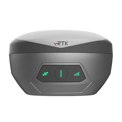
vRTK GNSS RTK System
Equipped with professional dual cameras, vRTK is Hi-Target first lightweight and innovative visual RTK receiver product, which not only enables non-contact image surveying, breaking through the objective constraints of previous work, but also improves the speed of stakeout with the function of Live View Stakeout. It greatly improves the work efficiency of engineering users.
Dual Cameras for Image Survey and Live View Stakeout
Non-contact measurement greatly improves the usable range of GNSS and efficient safe operation.
Strong Signal and High-quality Data
- New generation GNSS SOC chip with 1408 channels, supports new frequency points B1C, B2a, and B2b RTK decoding for Beidou-3 Satellites.
- Introduction of multi-frequency anti-jamming technology and multi-step adaptive filtering technology to ensure strong signals, high-quality data, fast fix, and high accuracy.
Abundant Industry Data Results
- Abundant types of data results meet the needs of different industry applications.
- Compatible with the mainstream modelling software to attain point cloud and 3D modelling in one step.
Product Parameters:
- Tilt Survey Accuracy: 8mm+0.7mm/°tilt
- Channels: 1408/1760
- Satellite Tracking: BDS/GPS/GLONASS/GALILEO/QZSS/NavlC/SBAS
- Image Stakeout Accuracy: 2cm
- Image Survey Accuracy: 2cm ~ 4cm
- Data Storage: Built-in 8GB ROM
نظام vRTK GNSS RTK
مزود بكاميرتين احترافيتين، يُعتبر جهاز vRTK أول منتج خفيف الوزن ومبتكر من Hi-Target في فئة أجهزة استقبال RTK البصرية. يتميز بتمكين المسح التصويري دون تلامس، متغلبًا على القيود الموضوعية للأعمال السابقة، بالإضافة إلى تحسين سرعة التحديد باستخدام وظيفة التحديد المباشر “Live View Stakeout”، مما يعزز بشكل كبير كفاءة عمل المستخدمين الهندسيين.
كاميرتان للمسح التصويري والتحديد المباشر
القياس دون تلامس يزيد بشكل كبير من نطاق استخدام GNSS ويوفر عملية آمنة وفعالة.
إشارة قوية وبيانات عالية الجودة
- شريحة GNSS SOC من الجيل الجديد مع 1408 قناة، تدعم النقاط الترددية الجديدة B1C، B2a، وB2b لفك شيفرة RTK لأقمار Beidou-3 الصناعية.
- تقنيات مقاومة التشويش متعددة التردد وتقنيات التصفية التكيفية متعددة المراحل تضمن إشارات قوية وبيانات عالية الجودة وسرعة تثبيت ودقة فائقة.
نتائج بيانات صناعية وفيرة
- أنواع متعددة من نتائج البيانات تلبي احتياجات التطبيقات الصناعية المختلفة.
- متوافق مع برامج النمذجة الرئيسية للحصول على السحابة النقطية والنمذجة ثلاثية الأبعاد بخطوة واحدة.
معلومات المنتج:
- دقة المسح المائل: 8mm+0.7mm/°tilt
- عدد القنوات: 1408/1760
- تتبع الأقمار الصناعية: BDS/GPS/GLONASS/GALILEO/QZSS/NavlC/SBAS
- دقة التحديد التصويري: 2 سم
- دقة المسح التصويري: 2 سم ~ 4 سم
- سعة التخزين: ذاكرة داخلية 8GB ROM


المراجعات
لا توجد مراجعات بعد.